The Cascade Range (or Cascades) is a major mountain range of western North America, extending from southern British Columbia through Washington and Oregon to Northern California. It includes both non-volcanic mountains, such as the North Cascades, and the notable volcanoes known as the High Cascades. The small part of the range in British Columbia is called the Canadian Cascades or Cascade Mountains; the latter term is also sometimes used by Washington residents to refer to the Washington section of the Cascades in addition to North Cascades, the more usual American term, as in North Cascades National Park.
The Cascades are part of the Pacific Ring of Fire, the ring of volcanoes and associated mountains around the Pacific Ocean. All of the known historic eruptions in the contiguous United States have been from Cascade volcanoes. The two most recent were Lassen Peak in 1914 to 1921 and a major eruption of Mount St. Helens in 1980. Minor eruptions of Mount St. Helens have also occurred since, most recently in 2006. The tallest mountain in the Cascade Range is Mount Rainier
Geography[]
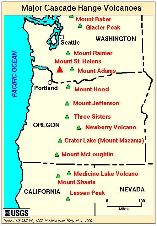
Major volcanic mountains along the Cascade Range.
The Cascade Mountains extend from Lassen Peak (also known as Mount Lassen) (3170 m) in northern California to Lytton Mountain (2,049 m) in Canada, near the confluence of the Fraser and Thompson Rivers. The tallest volcanoes of the Cascades are called the High Cascades and dominate their surroundings, often standing twice the height of the nearby mountains. They often have a visual height (height above nearby crestlines) of one mile or more. The tallest peaks, such as the 14,411 foot high Mount Rainier, dominate their surroundings for 50 to 100 miles
The northern part of the range, north of Mount Rainier, is known as the North Cascades in the United States but is formally named the Cascade Mountains north of the US-Canada border, reaching to the northern extremity of the Cascades at Lytton Mountain, just southwest of the confluence of the Fraser and Thompson Rivers. Overall the North Cascades and southwestern Canadian Cascades are extremely rugged, with many of the lesser peaks steep and glaciated, with valleys quite low relative to its peaks and ridges, resulting in great local relief, and major passes are only about 1,000 m (3,300 ft) high. The southern part of the Canadian Cascades, particularly the Skagit Range, are geologically and topographically similar to the North Cascades, while the northern and northeastern parts - the Coquihalla Range, the name of which is unofficial, the northern half of the Hozameen Range and most of the Okanagan Range are less glaciated and more plateau-like in character, resembling nearby areas of the Thompson Plateau.
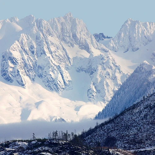
Snow covered Cascade Mountains in Washington State.
Because of the range's proximity to the Pacific Ocean, precipitation is substantial, especially on the western slopes, with annual accumulations of up to 150 inches (3,800 mm) in some areas—Mount Baker, for instance, recorded the largest single-season snowfall on record in the world in 1999—and heavy snowfall as low as 2,000 feet (600 m). It is not uncommon for some places in the Cascades to have over 200 inches (5,500 mm) of snow accumulation, such as at Lake Helen (near Lassen Peak), one of the snowiest places in the world. Most of the High Cascades are therefore white with snow and ice year-round. The western slopes are densely covered with Douglas-fir, Western Hemlock and Red alder, while the drier eastern slopes are mostly Ponderosa Pine, with Western Larch at higher elevations. Annual rainfall drops to 9 inches (200 mm) on the eastern foothills due to a rainshadow effect.
Beyond the foothills is an arid plateau that was created 16 million years ago as a coalescing series of layered flood basalt flows. Together, these sequences of fluid volcanic rock form a 200,000 square mile region out of eastern Washington, Oregon, and parts of Northern California and Idaho called the Columbia River Plateau.
The Columbia River Gorge is the only major break in the American part of the Cascades. When the Cascades started to rise thousands of years ago, the Columbia River drained the relatively low Columbia River Plateau. As the range grew, the Columbia was able to keep pace, creating the gorge and major pass seen today. The gorge also exposes uplifted and warped layers of basalt from the plateau.
Geology[]
The Cascade Range is made up of a band of thousands of very small, short-lived volcanoes that have built a platform of lava and volcanic debris. Rising above this volcanic platform are a few strikingly large volcanoes, like Mount St. Helens, that dominate the landscape.
The Cascade volcanoes define the Pacific Northwest section of the Ring of Fire, an array of volcanoes that rim the Pacific Ocean. The Ring of Fire is also known for its frequent earthquakes. The volcanoes and earthquakes arise from a common source: subduction, where the dense Juan de Fuca oceanic plate plunges beneath the North American Plate.
As the oceanic slab sinks deep into the Earth's interior beneath the continental plate, high temperatures and pressures allow water molecules locked in the minerals of solid rock to escape. The water vapor rises into the pliable mantle above the subducting plate, causing some of the mantle to melt. This newly formed magma rises toward the Earth's surface to erupt, forming a chain of volcanoes (the Cascade Volcanic Arc) above the subduction zone.
Ecology[]
Forests of large, coniferous trees (western red cedars, Douglas-firs, western hemlocks, firs, pines, spruces, and others) dominate most of the Cascade Range. Cool, wet winters and warm, dry summers (largely a result of oceanic influence) favor evergreen species, whereas mild temperatures and rich soils promote fast and prolonged growth.
As a traveler passes through the Cascade Range, the climate first gets colder, then warmer and drier east of the crest.[33] Most of the Cascades' lower and middle elevations are covered in coniferous forest; the higher altitudes have extensive meadows as well as alpine tundra and glaciers. The southern part of the Cascades are within the California Floristic Province, an area of high biodiversity.
Black bears, coyotes, bobcats, cougars, beavers, deer, elk, moose, mountain goats and a few wolf packs returning from Canada live in the Cascades. Fewer than 50 grizzly bears reside in the Cascades of Canada and Washington.
Tallest Cascade Range Mountains In Washington[]
| Rank | Summit | Height (ft) |
|---|---|---|
| 1 | Mount Rainier | 14,417 |
| 2 | Mount Adams | 12,281 |
| 3 | Little Tahoma | 11,143 |
| 4 | Mount Baker | 10,786 |
| 5 | Glacier Peak | 10,541 |
| 6 | Bonanza Peak | 9,516 |
| 7 | Mount Staurt | 9,420 |
| 8 | Mount Fernow | 9,254 |
| 9 | Goode Mountain | 9,220 |
| 10 | Mount Shuksan | 9,135 |